Arnhem Liberation Route
-
What:
Cycling route -
Distance:
42 km

The Arnhem-Wageningen area was the scene of fierce fighting during the Second World War. On this route, you’ll follow the Rhine for part of the way, cross the river via the John Frost Bridge in Arnhem and pass through some of the paratroopers’ landing zones.
The area between Arnhem and Wageningen was the scene of fierce fighting during the Second World War. The much-discussed, failed Allied operation ‘Market Garden’ claimed thousands of lives in September 1944. The ‘Liberation Route Arnhem’ begins in the Planken Wambuis nature reserve. You then cycle towards the Airborne Museum at Hartenstein, where you’ll learn all about the Battle of Arnhem. Afterwards, you’ll follow a stretch of the Rhine and cross the river via the John Frost Bridge. This bridge is also popularly known as the ‘Bridge Too Far’, after the famous film about the battle for the bridge between the Germans and the British. You’ll also pass through part of the landing zones used by the paratroopers in September 1944.
Would you like to shorten or extend your route along the way? At every junction, you’ll find a map on the information panel, allowing you to easily adjust your route yourself.
Here’s what you’ll see
-
12
-
97
-
45
-
44
-
Airborne Museum Hartenstein
Airborne Museum Hartenstein
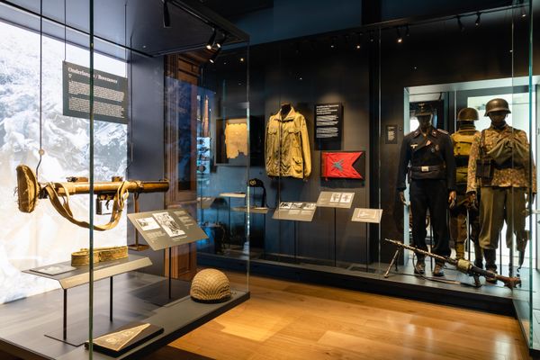
Experience the Battle of Arnhem at the site where British airborne troops had their headquarters in 1944. Explore personal stories and original artefacts, and step into the underground Airborne Experience at Villa Hartenstein. Read more
-
39
-
94
-
41
-
54
-
36
-
29
-
86
-
28
-
87
-
27
-
59
-
53
-
37
-
09
-
07
-
82
-
84
-
85
-
12
- 12
- 97
- 45
- 44
- 39
- 94
- 41
- 54
- 36
- 29
- 86
- 28
- 87
- 27
- 59
- 53
- 37
- 09
- 07
- 82
- 84
- 85
- 12